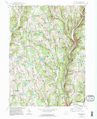
1994 Map of Hop Bottom
USGS Topo · Published 1995About this map
Hop Bottom and the valley of Martin Creek define this section of Susquehanna County, where the topography is shaped by countless glacial kettle ponds and wetlands. Small settlements like Lindaville, Hillsdale, and Deckertown are scattered among a complex network of high ridges, including Coon Hill and Nicholson Hill. The landscape is a mix of agricultural fields and active resource extraction, with several Quarries dotting the hillsides above the creek beds. A significant Pipeline corridor cuts across the terrain, reflecting the modern industrial layers superimposed over older 19th-century patterns.
Find a feature on this map
56 named features on this map. Tap any name to fly to it.
Don’t see what you’re looking for? This feature index may not catch every label — zoom into the map to look around manually.
Map Details
Editions of this 1994 Hop Bottom Map
This is the sole edition of this map. No revisions or reprints were ever made.
Other maps of this area

1892 · Dundaff
USGS Topo · 1:62,500

1932 · Susquehanna
USGS Topo · 1:62,500

1935 · Susquehanna
USGS Topo · 1:62,500

1943 · Montrose
USGS Topo · 1:62,500

1945 · Montrose
USGS Topo · 1:62,500

1946 · Tunkhannock
USGS Topo · 1:62,500

1946 · Dalton
USGS Topo · 1:24,000

1946 · Factoryville
USGS Topo · 1:24,000

1946 · Springville
USGS Topo · 1:24,000

1946 · Hop Bottom
USGS Topo · 1:24,000
Featured Places
- Lenox Township, PA
- Springville Township, PA
- Harford Township, PA
- Dimock Township, PA
- Brooklyn Township, PA