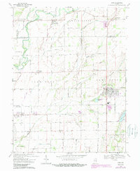
1968 Map of Hope
USGS Topo · Published 1993About this map
The Flatrock River winds through the northwest corner of this rural landscape, defining the agricultural character of northeastern Bartholomew County. The town of Hope serves as the primary hub, surrounded by a dense network of numbered country roads that link smaller farming communities and family landmarks. Throughout the mid-20th century, this area maintained a balance between its original 19th-century church and cemetery sites, such as Roberts Chapel and Sidney Branch Cem, and emerging infrastructure like the Sewage Disposal Ponds and electrical Substation.
Find a feature on this map
53 named features on this map. Tap any name to fly to it.
Don’t see what you’re looking for? This feature index may not catch every label — zoom into the map to look around manually.
Map Details
Editions of this 1968 Hope Map
Other maps of this area

1942 · Columbus
USGS Topo · 1:125,000

1947 · Hope
USGS Topo · 1:24,000

1948 · Edinburg
USGS Topo · 1:24,000

1948 · Hope
USGS Topo · 1:24,000

1948 · Lewis Creek
USGS Topo · 1:24,000

1948 · Marietta
USGS Topo · 1:24,000

1950 · Edinburg
USGS Topo · 1:62,500

1953 · Cincinnati
USGS Topo · 1:250,000

1956 · Waldron
USGS Topo · 1:24,000

1957 · Cincinnati
USGS Topo · 1:250,000