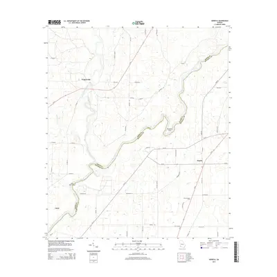
2014 Map of Hopeful
USGS Topo · Published 2014About this map
Flint River forms the central spine of this Southwest Georgia landscape, winding through the boundary between Baker and Mitchell Counties. The river's path is marked by distinctive navigation points such as Horseshoe Bend and the ominously named Hell Gate Shoals. To the west, Ichawaynochaway Creek and Big Cypress Cr contribute to the intricate drainage of this agricultural region. Small settlements like Hoggard Mill, Hopeful, and Lamar are connected by a network of county roads, reflecting the rural character of the area in the early 21st century. The Hopeful Lookout Tower stands as a prominent landmark on the eastern side of the river, while numerous local routes like Old Store Rd and Fire Tower Rd suggest the historical locations of community commerce and forestry infrastructure. The map documents a landscape where traditional river geography meets modern secondary highways.
Find a feature on this map
49 named features on this map. Tap any name to fly to it.
Don’t see what you’re looking for? This feature index may not catch every label — zoom into the map to look around manually.
Map Details
Editions of this 2014 Hopeful Map
This is the sole edition of this map. No revisions or reprints were ever made.
Other maps of this area

1953 · Dothan
USGS Topo · 1:250,000

1954 · Dothan
USGS Topo · 1:250,000

1955 · Dothan
USGS Topo · 1:250,000

1956 · Newton
USGS Topo · 1:62,500

1971 · Gee Pond
USGS Topo · 1:24,000

1971 · Vada
USGS Topo · 1:24,000

1971 · Hopeful
USGS Topo · 1:24,000
1971 · Branchville
USGS Topo · 1:24,000

1974 · Cooktown
USGS Topo · 1:24,000

1974 · Elmodel
USGS Topo · 1:24,000