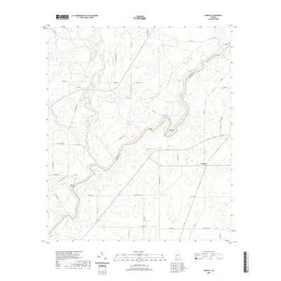
2020 Map of Hopeful
USGS Topo · Published 2020About this map
The Flint River carves a dramatic, winding path through this corner of Southwest Georgia, marking the boundary between Baker and Mitchell counties. Near the community of Hopeful, the river creates sharp meanders including the prominent Horseshoe Bend, and passes the descriptive Hell Gate Shoals. This landscape is characterized by a high density of small depressional wetlands and ponds, a signature of the local karst topography, which contrast with the defined drainages of Ichawaynochaway Creek and Big Cypress. The road network is primarily composed of local routes like Hoggard Mill Rd and Julienne Shed Rd, reflecting a rural agricultural and timber-based economy. For researchers, the map provides a contemporary view of family-named roads and remote crossroads like Old Store Rd, preserving the names of local landmarks and historical gathering points within the river-basin wilderness.
Find a feature on this map
47 named features on this map. Tap any name to fly to it.
Don’t see what you’re looking for? This feature index may not catch every label — zoom into the map to look around manually.
Map Details
Editions of this 2020 Hopeful Map
This is the sole edition of this map. No revisions or reprints were ever made.
Other maps of this area

1953 · Dothan
USGS Topo · 1:250,000

1954 · Dothan
USGS Topo · 1:250,000

1955 · Dothan
USGS Topo · 1:250,000

1956 · Newton
USGS Topo · 1:62,500

1971 · Gee Pond
USGS Topo · 1:24,000

1971 · Vada
USGS Topo · 1:24,000

1971 · Hopeful
USGS Topo · 1:24,000
1971 · Branchville
USGS Topo · 1:24,000

1974 · Cooktown
USGS Topo · 1:24,000

1974 · Elmodel
USGS Topo · 1:24,000