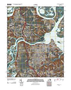
2010 Map of Hopewell
USGS Topo · Published 2010About this map
The Appomattox River and James River converge at City Point in this 2010 survey of Hopewell, Virginia. This landscape is defined by its strategic peninsulas and islands, including Presque Isle, Turkey Island, and Farrar Island. The transition from rural history to modern industrial infrastructure is evident, with traditional sites like Shirley and Walthall Mill situated near the Hopewell Regional Waste Water Treatment Facility. Residential expansion is visible through established neighborhoods such as Highland Park, Arlington, and Five Forks. Genealogy and local history researchers can identify numerous historic burial grounds, from the City Point National Cemetery and Appomattox Cemetery to the smaller Vaughan-Eyler Family Cemetery. The map also captures the legacy of the local economy through labels for Manchester Mill and the expansive Bermuda Golf Course, illustrating the evolving land use of these historic tidewater necks.
Find a feature on this map
107 named features on this map. Tap any name to fly to it.
Don’t see what you’re looking for? This feature index may not catch every label — zoom into the map to look around manually.
Map Details
Editions of this 2010 Hopewell Map
This is the sole edition of this map. No revisions or reprints were ever made.
Other maps of this area

1894 · Bermuda Hundred
USGS Topo · 1:62,500

1894 · Petersburg
USGS Topo · 1:62,500

1918 · Charles City
USGS Topo · 1:62,500

1919 · Disputanta
USGS Topo · 1:62,500

1938 · Dutch Gap
USGS Topo · 1:24,000

1938 · Drewrys Bluff
USGS Topo · 1:24,000

1943 · Dutch Gap
USGS Topo · 1:31,680

1943 · Hopewell
USGS Topo · 1:31,680

1943 · Disputanta
USGS Topo · 1:31,680

1943 · Richmond
USGS Topo · 1:250,000