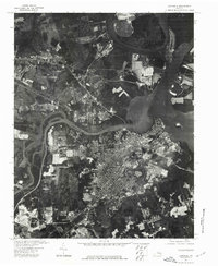
1974 Map of Hopewell
USGS Topo · Published 1977About this map
Hopewell sits at the strategic confluence where the Appomattox River meets the James River, a location that has historically defined this region’s industrial and maritime character. This 1974 orthophotoquad captures the city's mid-century footprint, showing the dense residential grid and the heavy industrial sites lining the riverbanks. The aerial perspective reveals the sharp contrast between the developed urban core of the city and the intricate, marshy islands and meandering channels of the James and Appomattox. This photographic record is particularly useful for observing land-use patterns and infrastructure as they existed in the mid-1970s, before later decades of redevelopment altered the waterfront and surrounding suburban landscapes.
Find a feature on this map
3 named features on this map. Tap any name to fly to it.
Don’t see what you’re looking for? This feature index may not catch every label — zoom into the map to look around manually.
Map Details
Editions of this 1974 Hopewell Map
This is the sole edition of this map. No revisions or reprints were ever made.
Other maps of this area

1894 · Bermuda Hundred
USGS Topo · 1:62,500

1894 · Petersburg
USGS Topo · 1:62,500

1918 · Charles City
USGS Topo · 1:62,500

1919 · Disputanta
USGS Topo · 1:62,500

1938 · Dutch Gap
USGS Topo · 1:24,000

1938 · Drewrys Bluff
USGS Topo · 1:24,000

1943 · Dutch Gap
USGS Topo · 1:31,680

1943 · Hopewell
USGS Topo · 1:31,680

1943 · Disputanta
USGS Topo · 1:31,680

1943 · Richmond
USGS Topo · 1:250,000