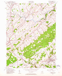
1954 Map of Hopewell
USGS Topo · Published 1963About this map
Sour Land Mountain and the neighboring Hopewell Mountain dominate the central relief of this mid-century New Jersey landscape, which spans the border of Hunterdon, Mercer, and Somerset counties. The borough of Hopewell sits at the foot of its namesake ridge, connected to the surrounding countryside by historical corridors such as Old York Road and Feather Bed Lane. The area is defined by a dense network of crossroad settlements and family-named locales like Larisons Corners, Purmans Corner, and Vanlieu Corners, indicating a deeply rooted agricultural and community structure.
Find a feature on this map
50 named features on this map. Tap any name to fly to it.
Don’t see what you’re looking for? This feature index may not catch every label — zoom into the map to look around manually.
Map Details
Editions of this 1954 Hopewell Map
4 editions found
Other maps of this area

1888 · Princeton
USGS Topo · 1:62,500

1890 · High Bridge
USGS Topo · 1:62,500

1890 · Lambertville
USGS Topo · 1:62,500

1891 · Somerville
USGS Topo · 1:62,500

1891 · Lambertville
USGS Topo · 1:62,500

1893 · Somerville
USGS Topo · 1:62,500

1894 · Princeton
USGS Topo · 1:62,500

1894 · Lambertville
USGS Topo · 1:62,500

1898 · High Bridge
USGS Topo · 1:62,500

1898 · Somerville
USGS Topo · 1:62,500
Featured Places
- Hillsborough Township, NJ
- Raritan Township, NJ
- Montgomery Township, NJ
- Hopewell Township, NJ
- Flemington, NJ