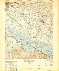
1948 Map of Hopkins
USGS Topo · Published 1948About this map
The Congaree River meanders through the heart of the Richland and Calhoun county borderlands, defining a landscape of dense swamps and oxbow lakes like Mullers Big Lake and Weston Lake. In the years following the war, this region south of Columbia reflects a heavy military and institutional presence, anchored by the Fort Jackson and Congaree Air Base reservations. The map reveals a deeply rooted rural community evidenced by the high density of small churches and schools, such as Daughters of St Matthews Church, Zion Pilgrim Ch, and the Lower Richland High Sch. Transport is dominated by the Southern and Atlantic Coast Line railroads, which connect agricultural settlements like Hopkins and Gadsden to the capital. From the industrial Sewage Disposal plant to the secluded Devils Orchard, the survey preserves a complex South Carolina transition between expanding military installations and traditional river-bottom settlements.
Find a feature on this map
114 named features on this map. Tap any name to fly to it.
Don’t see what you’re looking for? This feature index may not catch every label — zoom into the map to look around manually.
Map Details
Editions of this 1948 Hopkins Map
3 editions found

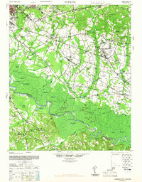
Other maps of this area

1904 · Columbia
USGS Topo · 1:125,000

1935 · Killian
USGS Topo · 1:48,000

1937 · Killian
USGS Topo · 1:62,500

1938 · Hagood
USGS Topo · 1:62,500

1941 · Spartanburg
USGS Topo · 1:250,000

1942 · Camden
USGS Topo · 1:125,000

1943 · Eastover
USGS Topo · 1:62,500

1944 · Edmund
USGS Topo · 1:62,500

1946 · Elloree
USGS Topo · 1:62,500

1946 · Woodford
USGS Topo · 1:62,500