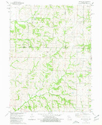
1980 Map of Hopkins SW
USGS Topo · Published 1980About this map
Wolf Creek and Clear Creek carve through the landscape along the state line between Iowa and Missouri, defining the rural character of this border region. The area is marked by several small, family-named burial sites such as Morehouse Cem and Shearer Cem, which suggest the deep-rooted agricultural settlement patterns of the late 20th century. Industrial activity is concentrated at a Quarry near the northern boundary, while modern infrastructure appears at a central Substation. The map reveals the township structure of the era, including Buchanan and Hopkins, showing a terrain largely dedicated to farming and sparse rural development. Waterways like Sink Creek dictate the local drainage, influencing the placement of early homesteads and roads that follow the natural contours of the land.
Find a feature on this map
20 named features on this map. Tap any name to fly to it.
Don’t see what you’re looking for? This feature index may not catch every label — zoom into the map to look around manually.
Map Details
Editions of this 1980 Hopkins SW Map
This is the sole edition of this map. No revisions or reprints were ever made.
Other maps of this area

1939 · Skidmore
USGS Topo · 1:62,500

1940 · Coin
USGS Topo · 1:62,500

1940 · New Market
USGS Topo · 1:62,500

1941 · Skidmore
USGS Topo · 1:62,500

1942 · Skidmore
USGS Topo · 1:62,500

1943 · Coin
USGS Topo · 1:62,500

1943 · Maryville
USGS Topo · 1:62,500

1943 · New Market
USGS Topo · 1:62,500

1955 · Nebraska City
USGS Topo · 1:250,000

1957 · Nebraska City
USGS Topo · 1:250,000