
1943 Map of New Market
USGS Topo · Published 1943About this map
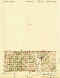
Hopkins serves as a central hub on this map of the borderlands between Iowa and Missouri, situated near the confluence of the West Fork, Middle Fork, and East Fork of the Hundred and Two River. The 1940 survey reveals a landscape defined by small-scale farming and local education, evidenced by a dense network of country schools such as Lone Elm Sch, Hickory Grove Sch, and Prairie Star Sch. The Chicago Burlington and Quincy railroad tracks cut through the river valley, providing the essential transport link for these rural townships in Atchison and Hopkins. Local family names and community history are preserved through numerous small burial grounds, including Johnson Cem and Morehouse Cem, which sit alongside landmarks like The Mound. The northern half of the map is largely marked as an Unsurveyed Area, focusing the cartographic detail on the settled southern portion during the early 1940s.
Find a feature on this map
39 named features on this map. Tap any name to fly to it.
Don’t see what you’re looking for? This feature index may not catch every label — zoom into the map to look around manually.
Map Details
Editions of this 1943 New Market Map
2 editions found
Other maps of this area

1939 · Skidmore
USGS Topo · 1:62,500

1940 · Bedford
USGS Topo · 1:62,500

1940 · Coin
USGS Topo · 1:62,500

1940 · New Market
USGS Topo · 1:62,500

1940 · Parnell
USGS Topo · 1:62,500

1941 · Skidmore
USGS Topo · 1:62,500

1942 · Skidmore
USGS Topo · 1:62,500

1943 · Bedford
USGS Topo · 1:62,500

1943 · Parnell
USGS Topo · 1:62,500

1943 · Coin
USGS Topo · 1:62,500