Loading...
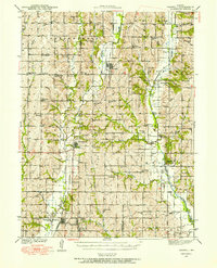
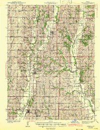
Loading map...1940 Map of Parnell
USGS Topo · Published 1954About this map
Parnell and the surrounding townships of Northwest Missouri show a landscape defined by small-town rail hubs and a dense network of rural schoolhouses just before the mid-century. The intersection of the Chicago Great Western and Wabash railroads at Conception Junction highlights the importance of rail transport to the regional economy, while the presence of the St Benedict Convent near Clyde marks a significant local landmark.
Find a feature on this map
61 named features on this map. Tap any name to fly to it.
Don’t see what you’re looking for? This feature index may not catch every label — zoom into the map to look around manually.
Map Details
Date Portrayed1940
Date Published1954
PublisherU.S. Geological Survey
Map TypeTopographic
Scale1:62,500
Physical Dimensions16.8 x 20.8 inches
Editions of this 1940 Parnell Map
This is the sole edition of this map. No revisions or reprints were ever made.
Historical Maps of Ravenwood Through Time
Featured Locations
- Cooper Township, MO
- Conception Junction, Jefferson Township
- Clyde, Jefferson Township
- Parnell, Independence Township
- Ravenwood, Jackson Township
Source Details
SourceU.S. Geological Survey
CopyrightPublic Domain