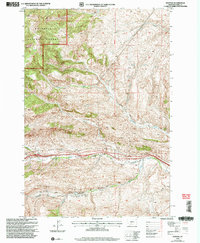
2000 Map of Hoppers
USGS Topo · Published 2005About this map
Cokedale Mines No 1 and Cokedale Mines No 2 anchor the industrial character of this landscape in the mountains east of Bozeman Pass. The area is defined by its coal mining history, where clusters of Mine Dumps and the remnants of Coke Ovens trace the lineage of early 20th-century extraction. Education in these rural outposts is marked by the Cokedale Sch and Haymond Sch, positioned near the small settlement of Hoppers. The terrain transitions from the protected slopes of the Gallatin National Forest and the Bozeman District into the drainage basins of Billman Creek and Fleshman Creek. Following the path of Cokedale Road, researchers can find specific Ruins and Springs that indicate the former extent of mining operations and remote homesteads in the high country.
Find a feature on this map
20 named features on this map. Tap any name to fly to it.
Don’t see what you’re looking for? This feature index may not catch every label — zoom into the map to look around manually.
Map Details
Editions of this 2000 Hoppers Map
This is the sole edition of this map. No revisions or reprints were ever made.
Other maps of this area

1891 · Livingston
USGS Topo · 1:250,000

1893 · Livingston
USGS Topo · 1:250,000

1947 · Bozeman
USGS Topo · 1:250,000

1948 · Bozeman
USGS Topo · 1:250,000

1951 · Bozeman Pass
USGS Topo · 1:62,500

1951 · Gobblers Knob
USGS Topo · 1:24,000

1951 · Chadborn
USGS Topo · 1:24,000

1951 · Brisbin
USGS Topo · 1:24,000

1951 · Hoppers
USGS Topo · 1:24,000

1951 · Chimney Rock
USGS Topo · 1:24,000