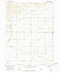
1962 Map of Hord
USGS Topo · Published 1963About this map
The Chicago Burlington and Quincy railroad cuts diagonally across the Platte River Valley in this mid-century portrait of Merrick County. This landscape is defined by its agrarian order, where township lines like Mead, Midland, and Lone Tree organize a network of section roads and numerous irrigation wells. The map reveals a robust educational and religious infrastructure serving the rural population, including School No 23, Mead Sch, Burke Sch, and the Nebraska Christian High Sch near the southern boundary.
Find a feature on this map
19 named features on this map. Tap any name to fly to it.
Don’t see what you’re looking for? This feature index may not catch every label — zoom into the map to look around manually.
Map Details
Editions of this 1962 Hord Map
2 editions found
Other maps of this area

1896 · Stromsburg
USGS Topo · 1:125,000

1899 · St. Paul
USGS Topo · 1:125,000

1955 · Belgrade SW
USGS Topo · 1:24,000

1955 · Broken Bow
USGS Topo · 1:250,000

1955 · Belgrade SE
USGS Topo · 1:24,000

1955 · Fremont
USGS Topo · 1:250,000

1956 · Broken Bow
USGS Topo · 1:250,000

1957 · Fremont
USGS Topo · 1:250,000

1958 · Fremont
USGS Topo · 1:250,000

1958 · Fullerton
USGS Topo · 1:24,000