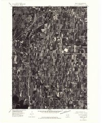
1975 Map of Horicon NE
USGS Topo · Published 1977About this map
Agricultural patterns and extensive wetlands dominate this mid-1970s orthophotoquad of Dodge County. The eastern fringe of the Horicon Marsh Wildlife Area is visible along the western margin, illustrating the sharp transition between protected marshland and the rectilinear grid of Wisconsin dairy country. This aerial view provides a literal snapshot of the landscape's texture, showing the dense woodlots and sprawling fields that surround the local centers of Mayville and Iron Ridge. To the south, the waters of Sinnissippi Lake break the terrestrial pattern, serving as a primary hydrologic feature. The map reveals the precise layout of farmsteads and transport corridors connecting these rural hubs, including the residential footprint of Horicon at the marsh's edge.
Find a feature on this map
5 named features on this map. Tap any name to fly to it.
Don’t see what you’re looking for? This feature index may not catch every label — zoom into the map to look around manually.
Map Details
Editions of this 1975 Horicon NE Map
This is the sole edition of this map. No revisions or reprints were ever made.
Other maps of this area

1904 · Hartford
USGS Topo · 1:62,500

1955 · Waupun
USGS Topo · 1:62,500

1955 · Campbellsport
USGS Topo · 1:62,500

1955 · Horicon
USGS Topo · 1:62,500

1957 · Madison
USGS Topo · 1:250,000

1959 · Hartford
USGS Topo · 1:62,500

1959 · Nenno
USGS Topo · 1:24,000
1959 · Hartford West
USGS Topo · 1:24,000

1960 · Madison
USGS Topo · 1:250,000
1974 · Lomira
USGS Topo · 1:24,000