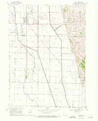
1969 Map of Hornick
USGS Topo · Published 1971About this map
Hornick serves as the primary hub in this Iowa landscape, where the confluence of managed water systems and rail transport defined the local economy during the late 1960s. The town's layout is marked by its proximity to the Chicago Milwaukee St Paul and Pacific railroad, which cuts diagonally across the township lines of West Fork and Willow. The terrain is defined by an extensive network of drainage infrastructure, including the West Fork Ditch, Garretson Outlet Ditch, and Farmers Levee Ditch, illustrating the mid-century engineering required to manage the floodplains of the Little Sioux River and Wolf Creek. To the east, the topography shifts abruptly toward the Grant uplands, where family-named landmarks like Tom King Hollow and Cottonwood Hollow offer a contrast to the surveyed flatlands and the small settlement at Grant Center.
Find a feature on this map
24 named features on this map. Tap any name to fly to it.
Don’t see what you’re looking for? This feature index may not catch every label — zoom into the map to look around manually.
Map Details
Editions of this 1969 Hornick Map
This is the sole edition of this map. No revisions or reprints were ever made.
Other maps of this area

1954 · Fort Dodge
USGS Topo · 1:250,000

1955 · Sioux City
USGS Topo · 1:250,000

1957 · Fort Dodge
USGS Topo · 1:250,000

1958 · Sioux City
USGS Topo · 1:250,000

1958 · Fort Dodge
USGS Topo · 1:250,000

1959 · Sioux City
USGS Topo · 1:250,000

1964 · Climbing Hill
USGS Topo · 1:24,000

1964 · Luton
USGS Topo · 1:24,000

1969 · Castana
USGS Topo · 1:24,000

1969 · Onawa
USGS Topo · 1:24,000