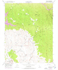
1947 Map of Hornitos
USGS Topo · Published 1977About this map
The Hunter Range dominates this portion of Mariposa County, where the gold-bearing landscape is densely marked by the remains of nineteenth-century quartz mining. The settlement of Hornitos sits at the southwestern edge of the survey, surrounded by extensive tailings that signal the scale of historic excavation along Hornitos Creek. A distinct industrial pattern emerges through the placement of the Mt Gaines Mine, Number Nine Mine, and the Oaks and Reese Mine, many of which are linked to the rugged drainage of Burns Creek. To the north, the rising waters of Lake Mc Clure reach into the canyons of the Merced River near Bagby, while inland features like the Quartzburg Sch and Williams Ranch provide markers of the region's agricultural and community life during the mid-twentieth century.
Find a feature on this map
35 named features on this map. Tap any name to fly to it.
Don’t see what you’re looking for? This feature index may not catch every label — zoom into the map to look around manually.
Map Details
Editions of this 1947 Hornitos Map
3 editions found
Other maps of this area

1893 · Sonora
USGS Topo · 1:125,000

1896 · Sonora
USGS Topo · 1:125,000

1897 · Sonora
USGS Topo · 1:125,000

1898 · Sonora
USGS Topo · 1:125,000

1916 · Merced Falls
USGS Topo · 1:24,000

1919 · Indian Gulch
USGS Topo · 1:48,000

1919 · Haystack Mountain
USGS Topo · 1:31,680

1919 · Merced Falls
USGS Topo · 1:31,680

1920 · Indian Gulch
USGS Topo · 1:62,500

1944 · Merced Falls
USGS Topo · 1:62,500