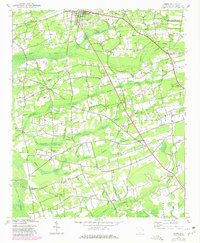
1943 Map of Horry
USGS Topo · Published 1980About this map
Aynor sits at the northern edge of this coastal plain landscape, where a network of rural crossroads and scattered settlements defines the inland character of Horry County. Based on 1943 surveys with 1980 photorevisions, the map reveals a community structured around small churches and schools such as St Elizabeth Ch, Pisgah Ch, and High Point Sch. The terrain is dominated by an intricate system of wetlands and branches, including Chinners Swamp and the expansive Little Pee Dee Swamp in the southwest corner. These natural features dictated the placement of early homesteads and travel routes, connecting locales like Jones Crossroads and Salem Crossroads. Cultural landmarks such as the Lookout Tower and Dog Bluff provide distinct reference points within the wooded lowlands, while the placement of the Rogers Fallout shelter reflects mid-century civil defense priorities layered over an earlier agricultural foundation.
Find a feature on this map
39 named features on this map. Tap any name to fly to it.
Don’t see what you’re looking for? This feature index may not catch every label — zoom into the map to look around manually.
Map Details
Editions of this 1943 Horry Map
2 editions found
Other maps of this area

1943 · Dongola
USGS Topo · 1:24,000

1943 · Adrian
USGS Topo · 1:24,000

1943 · Horry
USGS Topo · 1:24,000

1943 · Conway
USGS Topo · 1:24,000

1944 · Adrian
USGS Topo · 1:31,680

1946 · Johnsonville
USGS Topo · 1:62,500

1947 · Centenary
USGS Topo · 1:24,000

1948 · Galivants Ferry
USGS Topo · 1:24,000

1948 · Bayboro
USGS Topo · 1:24,000

1949 · Bayboro
USGS Topo · 1:24,000