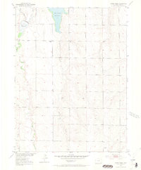
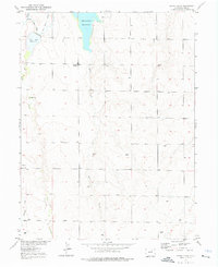
1952 Map of Horse Creek
USGS Topo · Published 1969About this map
Whittier School stands as a central landmark in this 1952 topographic study of the Adams County high plains, a region defined by its vital water management systems. The landscape is dominated by the storage and movement of water through the Horse Creek Reservoir and the Boot Lake Reservoir, which are fed and connected by the primary drainage of Horse Creek and its tributary Box Elder Creek. Surveyed as part of the Department of the Interior's program for the Missouri River Basin, the map reveals an arid terrain transformed by irrigation infrastructure like the High Line Lateral. The distribution of scattered Windmill sites across the township grids highlights the importance of groundwater for the remote farmsteads and ranching operations that characterize this portion of the Colorado plains during the mid-century era.
Find a feature on this map
8 named features on this map. Tap any name to fly to it.
Don’t see what you’re looking for? This feature index may not catch every label — zoom into the map to look around manually.
Map Details
Editions of this 1952 Horse Creek Map
5 editions found
Other maps of this area

1890 · East Denver
USGS Topo · 1:125,000

1902 · Greeley
USGS Topo · 1:125,000

1942 · Mile High Lakes
USGS Topo · 1:31,680

1942 · Box Elder School
USGS Topo · 1:31,680

1949 · Sunnydale
USGS Topo · 1:24,000

1949 · Bennett
USGS Topo · 1:24,000

1949 · Hudson
USGS Topo · 1:24,000

1950 · Keenesburg
USGS Topo · 1:24,000

1950 · Prospect Valley
USGS Topo · 1:24,000

1951 · Keenesburg
USGS Topo · 1:24,000