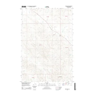
2014 Map of Horse Creek
USGS Topo · Published 2014About this map
Pumpkin Cr and its many seasonal tributaries dominate this Custer County landscape, carving through the high plains south of Miles City. The drainage network is dense and intricate, with Horse Cr, Dry Cr, and Prat Cr creating a complex series of draws and ridges. Elevated landmarks like Dug Long Hill and Gravel Hill provide topographic relief above the creek beds, while Jack Creek Divide in the southern portion of the map marks a significant watershed boundary. The area is intersected by MT-59, which follows the general orientation of the Pumpkin Cr valley. This 2014 survey captures a sparsely populated ranching region where water management is critical, evidenced by features such as the Pine Hill Reservoir. The map provides a clear record of the Public Land Survey System boundaries, including the intersection of multiple townships and ranges.
Find a feature on this map
20 named features on this map. Tap any name to fly to it.
Don’t see what you’re looking for? This feature index may not catch every label — zoom into the map to look around manually.
Map Details
Editions of this 2014 Horse Creek Map
This is the sole edition of this map. No revisions or reprints were ever made.
Other maps of this area

1953 · Miles City
USGS Topo · 1:250,000

1957 · Miles City
USGS Topo · 1:250,000

1958 · Miles City
USGS Topo · 1:250,000

1968 · Paddy Fay Creek
USGS Topo · 1:24,000

1969 · Horse Creek
USGS Topo · 1:24,000

1969 · Haines Springs
USGS Topo · 1:24,000

1969 · Circle L Creek
USGS Topo · 1:24,000

1969 · First Creek
USGS Topo · 1:24,000

1969 · Beebe SW
USGS Topo · 1:24,000
1969 · Beebe
USGS Topo · 1:24,000