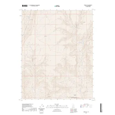
2023 Map of Horse Flat
USGS Topo · Published 2023About this map
Horse Flat and its surrounding plateau systems define this high-desert region of southern Utah. This landscape is deeply incised by a network of seasonal drainages, most notably Wahweap Creek and Coyote Creek, which have carved intricate canyon systems such as Coyote Canyon and Tommy Canyon. The map reveals a land utilized for its topographic vantage points, including the distinct Jack Riggs Bench and the prominent Coyote Point. Human presence is minimal and defined primarily by transit and name-bound landmarks like Cads Crotch and the winding Cottonwood Canyon Rd. This survey documents the complex drainage patterns and elevation changes across the Right Fork Chynoweth Canyon, providing a clear record of the area's physical geography as it remains today. The naming of smaller features like Tammy Smith Creek reflects the personal history and localized nomenclature often found in such isolated western territories.
Find a feature on this map
15 named features on this map. Tap any name to fly to it.
Don’t see what you’re looking for? This feature index may not catch every label — zoom into the map to look around manually.
Map Details
Editions of this 2023 Horse Flat Map
This is the sole edition of this map. No revisions or reprints were ever made.
Other maps of this area

1886 · Escalante
USGS Topo · 1:250,000

1922 · Upper Last Chance
USGS Topo · 1:63,360

1953 · Nipple Butte
USGS Topo · 1:62,500

1954 · Paria NW
USGS Topo · 1:24,000

1954 · Paria
USGS Topo · 1:62,500

1955 · The Cockscob SW
USGS Topo · 1:24,000

1956 · Escalante
USGS Topo · 1:250,000

1960 · Escalante
USGS Topo · 1:250,000

1964 · Horse Flat
USGS Topo · 1:24,000
1964 · Calico Peak
USGS Topo · 1:24,000