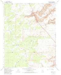
1968 Map of Horse Flat
USGS Topo · Published 1983About this map
Hualapai Indian Reservation lands dominate this high-desert landscape in Mohave County, where the plateau gives way to the deep incisions of Meriwhitica Canyon and Clay Canyon. The 1968 field survey reveals a terrain defined by water management and transit, where seasonal drainage from Lost Creek and the presence of scattered stock infrastructure like North Horse Flat Tank and Clay Tank were essential for land use. Human activity is concentrated along unpaved routes such as Buck and Doe Road and Clay Springs Road, which lead toward the isolated Ranger Cabin near a small Corral. To the northeast, the Lake Mead National Recreation Area boundary marks the transition toward the Colorado River's drainage system, while the namesake Horse Flat provides a relatively level expanse amidst the surrounding canyon network.
Find a feature on this map
27 named features on this map. Tap any name to fly to it.
Don’t see what you’re looking for? This feature index may not catch every label — zoom into the map to look around manually.
Map Details
Editions of this 1968 Horse Flat Map
3 editions found
Other maps of this area

1886 · Diamond Creek
USGS Topo · 1:250,000

1892 · Diamond Creek
USGS Topo · 1:250,000

1948 · Williams
USGS Topo · 1:250,000

1954 · Williams
USGS Topo · 1:250,000

1956 · Williams
USGS Topo · 1:250,000

1960 · Williams
USGS Topo · 1:250,000

1961 · Williams
USGS Topo · 1:250,000
1967 · Milkweed Canyon NW
USGS Topo · 1:24,000
1967 · Devils Slide Rapids
USGS Topo · 1:24,000
1967 · Spencer Canyon
USGS Topo · 1:24,000