
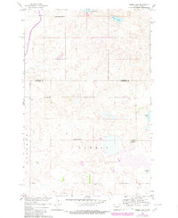
1960 Map of Horse Lake
USGS Topo · Published 1961About this map
Johns Lake and Horse Lake punctuate this high-plains landscape along the border of Sheridan and Burleigh Counties. The area is characterized by a high density of small, seasonal wetlands and prairie potholes, which dictate the winding paths of the local section roads. Rural life in the early 1960s centered on scattered community landmarks such as Johns Lake Ch and several local educational hubs, including Johns Lake Sch No 3, Schrunk Sch No 1, and Schrunk Sch No 2. This survey reflects the region's development during the Missouri River Basin project, capturing the exact placement of farmsteads and rural infrastructure before further agricultural consolidation. To the southeast, O'Brien Lake and Pelican Lake mark the lower elevations of the undulating terrain.
Find a feature on this map
11 named features on this map. Tap any name to fly to it.
Don’t see what you’re looking for? This feature index may not catch every label — zoom into the map to look around manually.
Map Details
Editions of this 1960 Horse Lake Map
2 editions found
Other maps of this area

1954 · McClusky
USGS Topo · 1:250,000

1958 · McClusky
USGS Topo · 1:250,000

1959 · Pickardville
USGS Topo · 1:24,000

1959 · Mercer SE
USGS Topo · 1:24,000

1959 · McClusky
USGS Topo · 1:24,000

1960 · Florence Lake
USGS Topo · 1:24,000

1960 · Denhoff
USGS Topo · 1:24,000
1979 · Regan
USGS Topo · 1:24,000

1979 · Canfield Lake
USGS Topo · 1:24,000
1979 · Wing
USGS Topo · 1:24,000