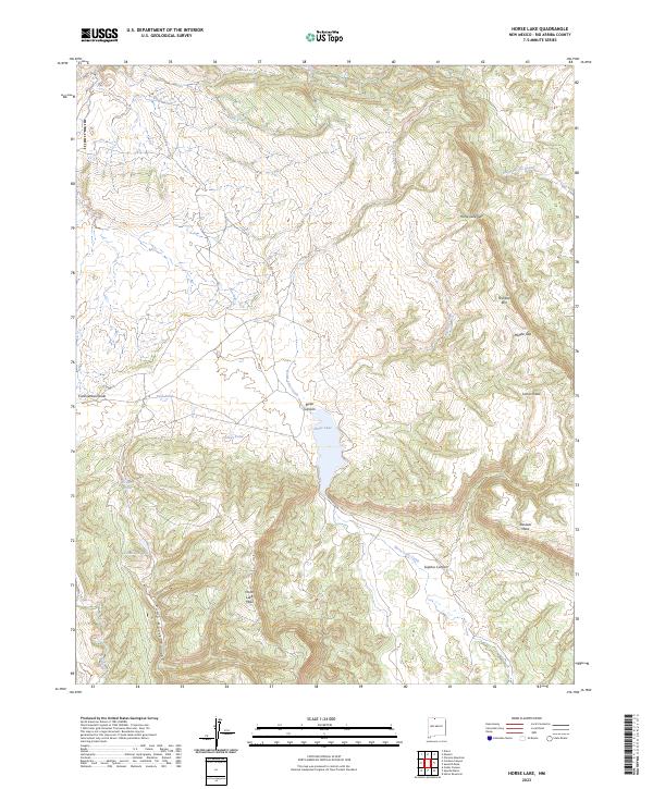
2023 Map of Horse Lake
USGS Topo · Published 2023About this map
Continental Divide winds through this high-elevation landscape in Rio Arriba County, where the topography is defined by significant mesas and steep drainage canyons. The namesake Horse Lake serves as a central hydrological feature, flanked by the massive Horse Lake Mesa to the south and the dramatic Tecolote Rim rising to the east. The drainage network is complex, with Horse Lake Creek and Boulder Creek cutting through terrain marked by deep features like Sulphur Canyon and Boiler Canyon. Numerous smaller water bodies, including Paiz Pond, Turkey Pond, Grouse Pond, and Cinnamon Lake, suggest a high-country environment where seasonal and permanent water sources were vital for local land use. This modern survey captures the enduring physical boundaries of the land, including the intersection of t30n r1e and t30n r2e, highlighting a region where natural barriers like Loma Prado and Horse Lake Gap have long dictated movement.
Find a feature on this map
24 named features on this map. Tap any name to fly to it.
Don’t see what you’re looking for? This feature index may not catch every label — zoom into the map to look around manually.
Map Details
Editions of this 2023 Horse Lake Map
This is the sole edition of this map. No revisions or reprints were ever made.
Other maps of this area

1954 · Aztec
USGS Topo · 1:250,000

1955 · Chama
USGS Topo · 1:62,500

1955 · Lumberton
USGS Topo · 1:62,500

1955 · Tierra Amarilla
USGS Topo · 1:62,500

1955 · Boulder Lake
USGS Topo · 1:62,500

1958 · Aztec
USGS Topo · 1:250,000

1962 · Aztec
USGS Topo · 1:250,000

1965 · Aztec
USGS Topo · 1:250,000

1981 · Chama
USGS Topo · 1:100,000
1983 · Dulce
USGS Topo · 1:24,000