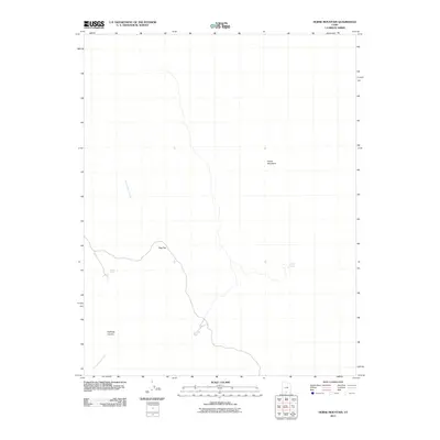
2011 Map of Horse Mountain
USGS Topo · Published 2011About this map
Horse Mountain dominates the high ground of this Kane County landscape, where the high desert terrain is defined by isolated water sources and sharp relief. In a region where reliable water is the primary factor for navigation and land use, named points like Tommy Water, Fourmile Water, and Kaibito Spring reveal the essential hydrology of the area. The map shows a transition from the elevated Dog Flat toward the deepening drainage of Halfmile Canyon, illustrating the complex erosional patterns typical of the southern Utah wilderness. This survey captures the rural character of the land as it remained in the early 21st century, prior to significant modern development. The network of seasonal drainages, including Tommy Smith Creek, underscores the environmental constraints that have historically shaped ranching and travel through this part of the Colorado Plateau.
Find a feature on this map
7 named features on this map. Tap any name to fly to it.
Don’t see what you’re looking for? This feature index may not catch every label — zoom into the map to look around manually.
Map Details
Editions of this 2011 Horse Mountain Map
This is the sole edition of this map. No revisions or reprints were ever made.
Other maps of this area

1886 · Escalante
USGS Topo · 1:250,000

1922 · Upper Last Chance
USGS Topo · 1:63,360

1956 · Escalante
USGS Topo · 1:250,000

1960 · Escalante
USGS Topo · 1:250,000

1964 · Horse Flat
USGS Topo · 1:24,000

1964 · Canaan Peak
USGS Topo · 1:24,000

1964 · Death Ridge
USGS Topo · 1:24,000

1964 · Carcass Canyon
USGS Topo · 1:24,000
1964 · Butler Valley
USGS Topo · 1:24,000

1968 · Fourmile Bench
USGS Topo · 1:24,000