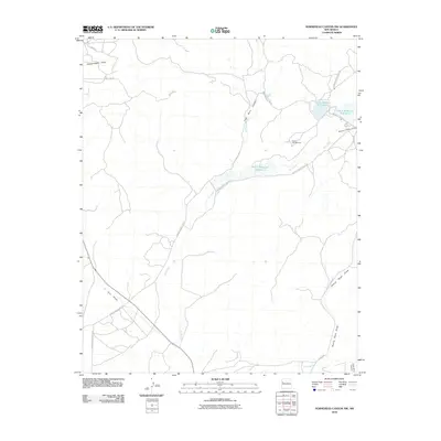
2010 Map of Horsehead Canyon NW
USGS Topo · Published 2010About this map
Rio Nutria flows through this high desert landscape, feeding a series of man-made catchments that supported the local ranching and tribal economy in the early 21st century. The map details the water management system of the Eastern Navajo Agency, specifically highlighting Nutria Reservoir Number 2, Nutria Reservoir Number 3, and Nutria Reservoir Number 4. These reservoirs are connected by a network of BIA roads, including Indian Service Route 28 and Indian Service Route 30, which traverse the drainage basins.
Find a feature on this map
18 named features on this map. Tap any name to fly to it.
Don’t see what you’re looking for? This feature index may not catch every label — zoom into the map to look around manually.
Map Details
Editions of this 2010 Horsehead Canyon NW Map
This is the sole edition of this map. No revisions or reprints were ever made.
Other maps of this area

1886 · Wingate
USGS Topo · 1:250,000

1892 · Wingate
USGS Topo · 1:250,000

1954 · Gallup
USGS Topo · 1:250,000

1958 · Gallup
USGS Topo · 1:250,000

1959 · Gallup
USGS Topo · 1:250,000

1962 · Gallup
USGS Topo · 1:250,000

1963 · Pinehaven
USGS Topo · 1:24,000
1963 · Upper Nutria
USGS Topo · 1:24,000
1963 · Vander Wagen
USGS Topo · 1:24,000

1967 · Gallup
USGS Topo · 1:250,000