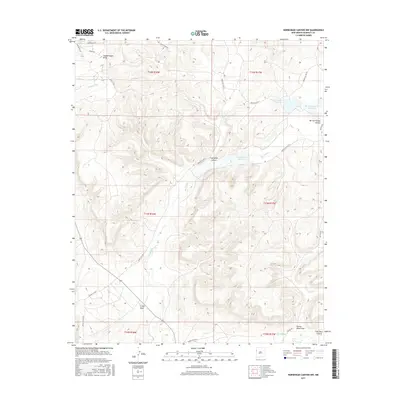
2017 Map of Horsehead Canyon NW
USGS Topo · Published 2017About this map
Rio Nutria flows through this high-desert landscape in the Eastern Navajo Agency, defining a corridor of vital water management in a drainage-carved terrain. The map documents a sophisticated series of catchments, including Nutria Reservoir Number 4, Nutria Reservoir Number 3, and Nutria Reservoir Number 2, which supported the region's agricultural and pastoral needs. The topography is deeply etched by seasonal watercourses and canyons, such as Coal Mine Canyon and Burned Timber Canyon, which demonstrate the natural erosion patterns of the McKinley County area. An extensive network of Bureau of Indian Affairs roads, such as Indian Svc Rte 7 and Indian Svc Rte 29, provides the primary infrastructure connecting these remote drainage basins and grazing lands, while the southern edge of the sheet transitions toward the Rio Pescado valley.
Find a feature on this map
29 named features on this map. Tap any name to fly to it.
Don’t see what you’re looking for? This feature index may not catch every label — zoom into the map to look around manually.
Map Details
Editions of this 2017 Horsehead Canyon NW Map
This is the sole edition of this map. No revisions or reprints were ever made.
Other maps of this area

1886 · Wingate
USGS Topo · 1:250,000

1892 · Wingate
USGS Topo · 1:250,000

1954 · Gallup
USGS Topo · 1:250,000

1958 · Gallup
USGS Topo · 1:250,000

1959 · Gallup
USGS Topo · 1:250,000

1962 · Gallup
USGS Topo · 1:250,000

1963 · Pinehaven
USGS Topo · 1:24,000
1963 · Upper Nutria
USGS Topo · 1:24,000
1963 · Vander Wagen
USGS Topo · 1:24,000

1967 · Gallup
USGS Topo · 1:250,000