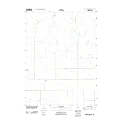
2011 Map of Horsehead Ranch
USGS Topo · Published 2011About this map
Horsehead Ranch lends its name to this high plains landscape of western Nebraska, where the drainage patterns of Middle Creek, Greenwood Creek, and Rush Creek define the topography. The map illustrates a sparse, ranch-oriented settlement pattern typical of Cheyenne County, with an organized grid of section roads such as Road 58 and Road 82 providing access to remote homesteads and agricultural tracts. Local history and genealogy interest is anchored by the Sanders Cemetery, a solitary burial site located south of the central creek beds. The presence of the Mayer Landing Strip near the western edge underscores the vast distances of the region, where private aviation serves as a vital link for rural ranching operations.
Find a feature on this map
17 named features on this map. Tap any name to fly to it.
Don’t see what you’re looking for? This feature index may not catch every label — zoom into the map to look around manually.
Map Details
Editions of this 2011 Horsehead Ranch Map
This is the sole edition of this map. No revisions or reprints were ever made.
Other maps of this area

1898 · Camp Clarke
USGS Topo · 1:125,000

1954 · Scottsbluff
USGS Topo · 1:250,000

1958 · Scottsbluff
USGS Topo · 1:250,000

1965 · Courthouse Rock
USGS Topo · 1:24,000

1972 · Mud Springs SW
USGS Topo · 1:24,000

1972 · Horsehead Ranch
USGS Topo · 1:24,000

1972 · Mud Springs SE
USGS Topo · 1:24,000
1972 · Mud Springs
USGS Topo · 1:24,000

1973 · Bridgeport SW
USGS Topo · 1:24,000

1973 · Potter 2 SE
USGS Topo · 1:24,000