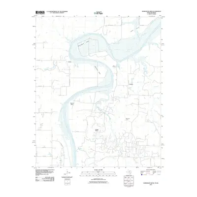
2010 Map of Horseshoe Bend
USGS Topo · Published 2010About this map
The Red River carves a complex, winding path through the borderlands of Texas and Oklahoma, forming the dramatic loops of Horseshoe Bend and Addington Bend. This landscape is defined by the shifting alluvial environment where wide sandbars and river channels intersect with established rural settlements. The small communities of Walnut Bend and Coesfield sit amidst a network of county roads, showing the persistent agricultural and industrial footprint in this river valley. Local history is anchored by the Decherds Cemetery and Black Cemetery, which represent the early family settlements of the area. Economic activity is highlighted by the Walnut Bend Oil Field, illustrating how natural resource extraction integrates into the floodplain. Smaller waterways like Hickory Creek and Dripping Spring feed into the main river channel, while Loves Valley opens up to the northeast, revealing the varied topography of this unique riverine border.
Find a feature on this map
43 named features on this map. Tap any name to fly to it.
Don’t see what you’re looking for? This feature index may not catch every label — zoom into the map to look around manually.
Map Details
Editions of this 2010 Horseshoe Bend Map
This is the sole edition of this map. No revisions or reprints were ever made.
Other maps of this area

1901 · Denison
USGS Topo · 1:125,000

1902 · Gainesville
USGS Topo · 1:125,000

1943 · Gainesville
USGS Topo · 1:125,000

1954 · Sherman
USGS Topo · 1:250,000

1958 · Gordonville
USGS Topo · 1:62,500

1958 · Whitesboro
USGS Topo · 1:62,500

1958 · Sherman
USGS Topo · 1:250,000

1960 · Callisburg
USGS Topo · 1:24,000

1960 · Gainesville North
USGS Topo · 1:24,000
1967 · Marietta East
USGS Topo · 1:24,000