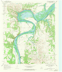
1968 Map of Horseshoe Bend
USGS Topo · Published 1971About this map
The Red River carves a dramatic, winding path along the border of Texas and Oklahoma in the late 1960s, defining a landscape shaped by petroleum extraction and riverine agriculture. Within the large meander of Walnut Bend, a dense concentration of oil wells and a refinery underscore the region's industrial importance, supported by a network of unimproved roads and a pumping station near Hickory Creek. Local life centers around small landmarks like the Walnut Bend Sch and Hibbit Ch, while the northern portion of the map shows the influence of water management with portions of Lake Texoma subject to controlled inundation. The Atchison Topeka and Santa Fe railroad skirts the northwestern corner, providing a vital transport link for Loves Valley and the surrounding borderlands near Decherds Camp.
Find a feature on this map
26 named features on this map. Tap any name to fly to it.
Don’t see what you’re looking for? This feature index may not catch every label — zoom into the map to look around manually.
Map Details
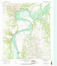
Editions of this 1968 Horseshoe Bend Map
2 editions found
Other maps of this area

1901 · Denison
USGS Topo · 1:125,000

1902 · Gainesville
USGS Topo · 1:125,000

1943 · Gainesville
USGS Topo · 1:125,000

1954 · Sherman
USGS Topo · 1:250,000

1958 · Gordonville
USGS Topo · 1:62,500

1958 · Whitesboro
USGS Topo · 1:62,500

1958 · Sherman
USGS Topo · 1:250,000

1960 · Callisburg
USGS Topo · 1:24,000

1960 · Gainesville North
USGS Topo · 1:24,000
1967 · Marietta East
USGS Topo · 1:24,000