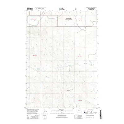
2015 Map of Horseshoe Bend
USGS Topo · Published 2015About this map
The Thunder Basin National Grassland dominates this landscape in northeastern Wyoming, where the high plains are carved by the winding course of the Cheyenne River. The river forms a prominent arc at Horse Shoe Bend in the northwest, a topographic landmark that anchors the surrounding rangeland. Human adaptation to this arid environment is evident in the scattered water management features, including the Zerbst Reservoir and Bob Dixon Number 1 Reservoir, which support livestock and wildlife in the basin.
Find a feature on this map
16 named features on this map. Tap any name to fly to it.
Don’t see what you’re looking for? This feature index may not catch every label — zoom into the map to look around manually.
Map Details
Editions of this 2015 Horseshoe Bend Map
This is the sole edition of this map. No revisions or reprints were ever made.
Other maps of this area

1899 · Newcastle
USGS Topo · 1:125,000

1901 · Newcastle
USGS Topo · 1:125,000

1955 · Newcastle
USGS Topo · 1:250,000

1958 · Newcastle
USGS Topo · 1:250,000

1979 · Newcastle
USGS Topo · 1:100,000

1981 · Horseshoe Bend
USGS Topo · 1:24,000

1981 · Threemile Butte
USGS Topo · 1:24,000

1981 · Dixon Ranch
USGS Topo · 1:24,000
1981 · Boggy Reservoir
USGS Topo · 1:24,000

1981 · Garland Draw
USGS Topo · 1:24,000