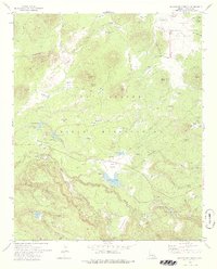
1978 Map of Horseshoe Cienega
USGS Topo · Published 1978About this map
The Mogollon Rim anchors the southern portion of this high-elevation landscape, where the Fort Apache Indian Reservation and Apache National Forest meet. This terrain is characterized by its numerous cienegas—alkaline marshes or wet meadows—such as Yellow Jacket Cienega, Old Corral Cienega, and Elk Spring Cienega. The map reveals a land utilized for both recreation and remote living, featuring Ryan Ranch and the Paradise Park Youth Camp along the river forks.
Find a feature on this map
74 named features on this map. Tap any name to fly to it.
Don’t see what you’re looking for? This feature index may not catch every label — zoom into the map to look around manually.
Map Details
Editions of this 1978 Horseshoe Cienega Map
2 editions found
Other maps of this area

1886 · St Johns
USGS Topo · 1:250,000

1892 · St Johns
USGS Topo · 1:250,000

1954 · Clifton
USGS Topo · 1:250,000

1954 · Saint Johns
USGS Topo · 1:250,000

1957 · Clifton
USGS Topo · 1:250,000

1957 · Saint Johns
USGS Topo · 1:250,000

1958 · Clifton
USGS Topo · 1:250,000

1958 · Saint Johns
USGS Topo · 1:250,000

1961 · McNary
USGS Topo · 1:62,500

1962 · Clifton
USGS Topo · 1:250,000