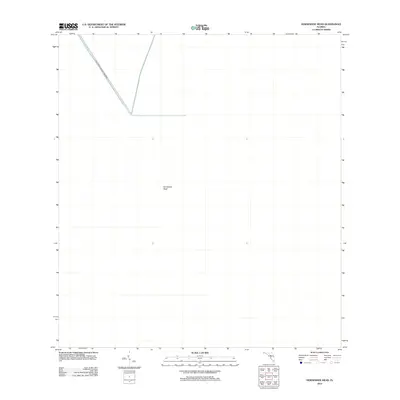
2012 Map of Horseshoe Head
USGS Topo · Published 2012About this map
Big Cypress National Preserve defines the northwestern corner of this territory, where the straight line of the Interceptor Canal cuts through the marshy landscape. The interior of the map is dominated by the vast, open wetlands of the Everglades, punctuated by the small settlement or landmark of Horseshoe Head. This 2012 survey reveals a landscape of massive environmental significance, primarily managed for conservation and water control rather than urban development. The presence of the canal and the national preserve boundary highlights the delicate balance of water management in Broward County, illustrating how engineered infrastructure and protected wilderness areas coexist in this specific part of southern Florida.
Find a feature on this map
3 named features on this map. Tap any name to fly to it.
Don’t see what you’re looking for? This feature index may not catch every label — zoom into the map to look around manually.
Map Details
Editions of this 2012 Horseshoe Head Map
This is the sole edition of this map. No revisions or reprints were ever made.
Other maps of this area

1956 · Miami
USGS Topo · 1:250,000

1956 · West Palm Beach
USGS Topo · 1:250,000

1957 · West Palm Beach
USGS Topo · 1:250,000

1958 · West Palm Beach
USGS Topo · 1:250,000

1958 · Miami
USGS Topo · 1:250,000

1973 · Custard Apple Hammock
USGS Topo · 1:24,000

1973 · Everglades 4 NW
USGS Topo · 1:24,000

1973 · North Of Fiftymile Bend
USGS Topo · 1:24,000
1973 · Everglades 4 SW
USGS Topo · 1:24,000

1973 · Everglades 3 NE
USGS Topo · 1:24,000