
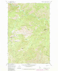
1965 Map of Horseshoe Lake
USGS Topo · Published 1967About this map
The Clearwater National Forest dominates this mid-1960s landscape, showcasing a primitive network of routes through the Idaho interior. The Lolo Trail and various stretches of Pack Trail underscore the historical importance of this corridor for travel across the Bitterroot Mountains. High-altitude landmarks like the Horseshoe Lake Lookout Tower and remote outposts such as Saddle Camp and Howard Camp serve as the primary human imprints on an otherwise wild terrain. Drainage patterns are intricately detailed, with Cayuse Creek winding through the northern reaches while the headwaters of West Fork Postoffice Creek and Serpent Creek carve through the southern slopes. The topography is defined by significant elevations including Lunde Peak, Moccasin Peak, and the distinctively named Devils Chair, providing a clear view of the region's geography before modern road expansion.
Find a feature on this map
28 named features on this map. Tap any name to fly to it.
Don’t see what you’re looking for? This feature index may not catch every label — zoom into the map to look around manually.
Map Details
Editions of this 1965 Horseshoe Lake Map
2 editions found
Other maps of this area

1911 · Lolo
USGS Topo · 1:250,000

1913 · Lolo
USGS Topo · 1:250,000

1956 · Hamilton
USGS Topo · 1:250,000

1959 · Hamilton
USGS Topo · 1:250,000

1960 · Hamilton
USGS Topo · 1:250,000

1964 · Hamilton
USGS Topo · 1:250,000

1965 · Scurvy Mtn.
USGS Topo · 1:24,000

1965 · Gorman Hill
USGS Topo · 1:24,000

1965 · Lookout Peak
USGS Topo · 1:24,000
1966 · Bear Mountain
USGS Topo · 1:24,000