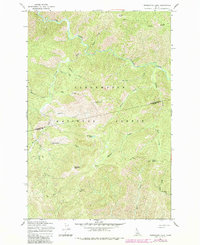
1965 Map of Horseshoe Lake
USGS Topo · Published 1984About this map
Clearwater National Forest dominates this mid-1960s survey, illustrating a remote landscape defined by the drainage basins of Cayuse Creek and its many tributaries. The area is characterized by high-elevation landmarks such as Lunde Peak and Moccasin Peak, which rise above the dense network of ridges. This map reveals a wilderness accessible primarily through historical routes like the Lolo Trail and various stretches of Pack Trail, reflecting the essential forest management and recreation infrastructure of the era. Evidence of human presence and administrative utility is found at the Horseshoe Lake Lookout Tower and remote stations like Howard Camp and Saddle Camp. The hydrology is particularly detailed, tracing the winding paths of Potato Creek, Weir Creek, and the uniquely named Postoffice Cr, providing a clear record of the watershed before later environmental shifts.
Find a feature on this map
28 named features on this map. Tap any name to fly to it.
Don’t see what you’re looking for? This feature index may not catch every label — zoom into the map to look around manually.
Map Details
Editions of this 1965 Horseshoe Lake Map
2 editions found
Other maps of this area

1911 · Lolo
USGS Topo · 1:250,000

1913 · Lolo
USGS Topo · 1:250,000

1956 · Hamilton
USGS Topo · 1:250,000

1959 · Hamilton
USGS Topo · 1:250,000

1960 · Hamilton
USGS Topo · 1:250,000

1964 · Hamilton
USGS Topo · 1:250,000

1965 · Scurvy Mtn.
USGS Topo · 1:24,000

1965 · Gorman Hill
USGS Topo · 1:24,000

1965 · Lookout Peak
USGS Topo · 1:24,000

1965 · Horseshoe Lake
USGS Topo · 1:24,000