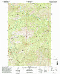
1994 Map of Horseshoe Lake
USGS Topo · Published 1998About this map
The Lewis and Clark National Historic Trail follows the high ridgelines of the Bitterroot Mountains in this 1990s revision, tracing a path through the heart of Clearwater National Forest. This remote backcountry landscape is defined by its dramatic drainage systems, where Cayuse Creek and its numerous tributaries like Potato Creek and Gravey Creek carve through the Idaho wilderness. Evidence of forest management and backcountry travel is visible through a network of established paths, including the North Fork Powell Trail and the Ranger District Trail. Notable high points like Moccasin Peak, Lunde Peak, and the distinctively named Devils Chair serve as natural landmarks. Further south, the map identifies specific backcountry sites such as Saddle Camp and Howard Camp, providing critical spatial context for the area's recreational and administrative history within the Clearwater and Idaho county borderlands near Horseshoe Lake.
Find a feature on this map
25 named features on this map. Tap any name to fly to it.
Don’t see what you’re looking for? This feature index may not catch every label — zoom into the map to look around manually.
Map Details
Editions of this 1994 Horseshoe Lake Map
This is the sole edition of this map. No revisions or reprints were ever made.
Other maps of this area

1911 · Lolo
USGS Topo · 1:250,000

1913 · Lolo
USGS Topo · 1:250,000

1956 · Hamilton
USGS Topo · 1:250,000

1959 · Hamilton
USGS Topo · 1:250,000

1960 · Hamilton
USGS Topo · 1:250,000

1964 · Hamilton
USGS Topo · 1:250,000

1965 · Scurvy Mtn.
USGS Topo · 1:24,000

1965 · Gorman Hill
USGS Topo · 1:24,000

1965 · Lookout Peak
USGS Topo · 1:24,000

1965 · Horseshoe Lake
USGS Topo · 1:24,000