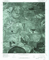
1975 Map of Horseshoe Lake NW
USGS Topo · Published 1976About this map
The town of Hughes anchors this 1970s orthophotograph, showing the precise grid of streets and buildings amidst a landscape defined by the ancient migrations of the Mississippi River. The geography is dominated by dramatic meander scars and oxbow features, most notably the wide arc of Council Lake and the meandering path of Fifteenmile Bayou. These water bodies and the smaller Crooked Bayou trace the delta's hydraulic history, where former river channels have been reclaimed for vast, geometric agricultural tracts. The aerial perspective captures the rural settlement at Penjur and the intricate drainage patterns of the Chute, providing a clear view of how human cultivation has adapted to the natural curves of the alluvial plain during the mid-1970s.
Find a feature on this map
6 named features on this map. Tap any name to fly to it.
Don’t see what you’re looking for? This feature index may not catch every label — zoom into the map to look around manually.
Map Details
Editions of this 1975 Horseshoe Lake NW Map
This is the sole edition of this map. No revisions or reprints were ever made.
Other maps of this area

1931 · Horseshoe Lake
USGS Topo · 1:62,500

1939 · Horseshoe Lake
USGS Topo · 1:62,500

1939 · Park Place
USGS Topo · 1:62,500

1939 · Edmondson
USGS Topo · 1:62,500

1940 · Whitmore
USGS Topo · 1:62,500

1948 · Helena
USGS Topo · 1:250,000

1950 · Helena
USGS Topo · 1:250,000

1953 · Memphis
USGS Topo · 1:250,000

1954 · Horseshoe Lake
USGS Topo · 1:62,500

1954 · Edmondson
USGS Topo · 1:62,500