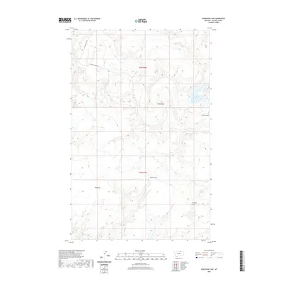
2020 Map of Horseshoe Lake
USGS Topo · Published 2020About this map
Sumner sits at the heart of this North Central Montana landscape, an area defined by its deep coulees and isolated prairie water features. The terrain is marked by seasonal drainage patterns including Alkali Coulee, Cowie Coulee, and Lambing Coulee, which carve through the high plains of Phillips County. The eponymous Horseshoe Lake remains a focal point in the northeast, set against a grid of sectional lines and rural routes like Sunnyslope Rd and Turner Cutacross Rd. This modern survey illustrates the persistent agricultural and ranching layout of the region, where the vast open spaces between Gloyn Coulee and the surrounding townships reflect the sparse settlement patterns typical of the Big Sky Country.
Find a feature on this map
10 named features on this map. Tap any name to fly to it.
Don’t see what you’re looking for? This feature index may not catch every label — zoom into the map to look around manually.
Map Details
Editions of this 2020 Horseshoe Lake Map
This is the sole edition of this map. No revisions or reprints were ever made.
Other maps of this area
1920 · Avery
USGS Topo · 1:125,000
1920 · Cowan
USGS Topo · 1:125,000
1953 · Havre
USGS Topo · 1:250,000

1954 · Glasgow
USGS Topo · 1:250,000

1957 · Glasgow
USGS Topo · 1:250,000
1957 · Havre
USGS Topo · 1:250,000

1958 · Glasgow
USGS Topo · 1:250,000
1958 · Havre
USGS Topo · 1:250,000
1984 · Chapman
USGS Topo · 1:24,000
1984 · Emerick Bench
USGS Topo · 1:24,000