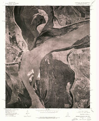
1975 Map of Horseshoe Lake SW
USGS Topo · Published 1976About this map
The Mississippi River dominates this orthophotoquad, defining the winding border between Arkansas and Mississippi in the mid-1970s. The aerial imagery captures the complex river morphology of the era, showcasing the massive sandbars and shifting channels that characterize this stretch of the waterway. On the western bank, the oxbow remnant of Council Lake sits near the small settlement of Council, while the community of Happy occupies the high ground to the northeast. To the southeast, the settlement of Commerce is positioned along the riverbank, surrounded by the geometric patterns of large-scale agricultural fields. This specific survey provides a clear view of the rural landscape and levee systems before further modern development altered the floodplain's appearance.
Find a feature on this map
5 named features on this map. Tap any name to fly to it.
Don’t see what you’re looking for? This feature index may not catch every label — zoom into the map to look around manually.
Map Details
Editions of this 1975 Horseshoe Lake SW Map
This is the sole edition of this map. No revisions or reprints were ever made.
Other maps of this area

1908 · Hollywood
USGS Topo · 1:24,000

1913 · Hollywood
USGS Topo · 1:31,680

1931 · Horseshoe Lake
USGS Topo · 1:62,500

1939 · Clayton
USGS Topo · 1:62,500

1939 · Horseshoe Lake
USGS Topo · 1:62,500

1939 · Park Place
USGS Topo · 1:62,500

1939 · Latour
USGS Topo · 1:62,500

1948 · Helena
USGS Topo · 1:250,000

1950 · Helena
USGS Topo · 1:250,000

1954 · Horseshoe Lake
USGS Topo · 1:62,500