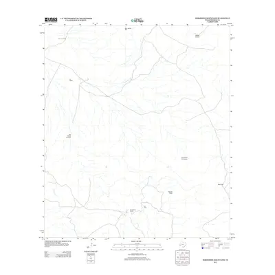
2012 Map of Horseshoe Mountains
USGS Topo · Published 2012About this map
San Jacinto Ranch and other remote ranching outposts define the high-desert landscape of this corner of Presidio County. In the early 21st century, the area remains dominated by vast open-range parcels and dramatic geological features, including the Horseshoe Mountains and the flat-topped Tascotal Mesa to the south. The distribution of Old Ranch and La Viuda suggests a sparse settlement pattern dictated by the few reliable water sources and navigable passes through the terrain. Evidence of modern infrastructure is seen at Rawls Ranch Airport, which serves this isolated interior. Steep drainages like Fishtail Canyon and Old Ranch Canyon channel seasonal runoff into Holguin Cr, while peaks like San Jacinto Mtn and the narrow passage at Wire Gap serve as essential landmarks for navigation across the high scrubland.
Find a feature on this map
11 named features on this map. Tap any name to fly to it.
Don’t see what you’re looking for? This feature index may not catch every label — zoom into the map to look around manually.
Map Details
Editions of this 2012 Horseshoe Mountains Map
This is the sole edition of this map. No revisions or reprints were ever made.
Other maps of this area

1896 · Shafter
USGS Topo · 1:125,000

1917 · Tascotal Mesa
USGS Topo · 1:62,500

1918 · Jordan Gap
USGS Topo · 1:62,500

1930 · Jordan Gap
USGS Topo · 1:62,500

1944 · Tascotal Mesa
USGS Topo · 1:62,500

1959 · Emory Peak
USGS Topo · 1:250,000

1959 · Presidio
USGS Topo · 1:250,000

1965 · Presidio
USGS Topo · 1:250,000

1965 · Emory Peak
USGS Topo · 1:250,000

1983 · Plata
USGS Topo · 1:24,000