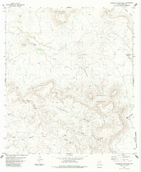
1983 Map of Horseshoe Mountains
USGS Topo · Published 1984About this map
San Jacinto Mountain dominates the northwestern corner of this West Texas landscape, where the high desert terrain is defined by deep canyons and isolated ranching outposts. This 1983 survey records a network of essential infrastructure for arid-land survival, including the Cripple Windmill and Dead Horse Windmill, alongside remote aviation markers like the Landing Strips situated south of Tascotal Mesa.
Find a feature on this map
23 named features on this map. Tap any name to fly to it.
Don’t see what you’re looking for? This feature index may not catch every label — zoom into the map to look around manually.
Map Details
Editions of this 1983 Horseshoe Mountains Map
This is the sole edition of this map. No revisions or reprints were ever made.
Other maps of this area

1896 · Shafter
USGS Topo · 1:125,000

1917 · Tascotal Mesa
USGS Topo · 1:62,500

1918 · Jordan Gap
USGS Topo · 1:62,500

1930 · Jordan Gap
USGS Topo · 1:62,500

1944 · Tascotal Mesa
USGS Topo · 1:62,500

1959 · Emory Peak
USGS Topo · 1:250,000

1959 · Presidio
USGS Topo · 1:250,000

1965 · Presidio
USGS Topo · 1:250,000

1965 · Emory Peak
USGS Topo · 1:250,000

1983 · Plata
USGS Topo · 1:24,000