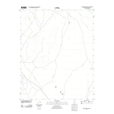
2011 Map of Horsethief Mesa
USGS Topo · Published 2011About this map
Horse Thief Mesa dominates the southern landscape of this Coconino County terrain, characterized by a complex network of ephemeral drainages and geologic formations. The area is defined by its drainage systems, including the prominent Peach Wash to the west and Kaibito Creek and Starting Water Wash to the northeast. Human presence is marked primarily by a sparse network of Forest Service roads that provide access through the arid topography. Notable landmarks such as Sitting Lizard Arch and Sitting Lizard Rock suggest a landscape shaped by distinct erosion patterns. Water resources appear limited to isolated features like Circular Tank, while vertical relief is identified by outcrops like Black Rock and Red Bluff. This 2011 survey illustrates a quiet, largely undeveloped portion of Northern Arizona where natural features and basic service routes are the primary identifiers.
Find a feature on this map
10 named features on this map. Tap any name to fly to it.
Don’t see what you’re looking for? This feature index may not catch every label — zoom into the map to look around manually.
Map Details
Editions of this 2011 Horsethief Mesa Map
This is the sole edition of this map. No revisions or reprints were ever made.
Other maps of this area

1886 · Echo Cliffs
USGS Topo · 1:250,000

1891 · Echo Cliffs
USGS Topo · 1:250,000

1954 · Leche-E Rock
USGS Topo · 1:62,500

1954 · Navajo Creek
USGS Topo · 1:62,500

1956 · Marble Canyon
USGS Topo · 1:250,000

1959 · Marble Canyon
USGS Topo · 1:250,000

1961 · Marble Canyon
USGS Topo · 1:250,000
1981 · Horsethief Mesa
USGS Topo · 1:24,000
1981 · Kaibito
USGS Topo · 1:24,000
1982 · White Hill
USGS Topo · 1:24,000