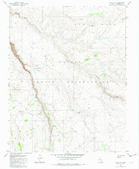
1982 Map of White Hill
USGS Topo · Published 1982About this map
The Navajo Indian Reservation landscape across this portion of Coconino County is defined by a complex system of plateaus and ephemeral drainage ways. High points like White Hill and Gray Mesa overlook the deep incision of Kaibito Canyon, where seasonal flows follow Kaibito Creek through the desert floor. This 1982 survey reveals a land managed for grazing and water access, documented through numerous livestock-related landmarks including the Lined Trees Windmill and various catchments such as Dejolie Tank and the Water Trough Well. Travel through this territory is marked by primitive 4wd tracks that navigate the breaks between the mesas and the stark rise of Red Bluff. The network of names like Starting Water Wash suggests a reliance on traditional water sources in a region where geography dictates the movement of people and animals.
Find a feature on this map
15 named features on this map. Tap any name to fly to it.
Don’t see what you’re looking for? This feature index may not catch every label — zoom into the map to look around manually.
Map Details
Editions of this 1982 White Hill Map
This is the sole edition of this map. No revisions or reprints were ever made.
Other maps of this area

1883 · Marsh Pass
USGS Topo · 1:250,000

1886 · Echo Cliffs
USGS Topo · 1:250,000

1891 · Echo Cliffs
USGS Topo · 1:250,000

1892 · Marsh Pass
USGS Topo · 1:250,000

1954 · Navajo Creek
USGS Topo · 1:62,500

1956 · Marble Canyon
USGS Topo · 1:250,000

1959 · Marble Canyon
USGS Topo · 1:250,000

1961 · Marble Canyon
USGS Topo · 1:250,000

1970 · Square Butte
USGS Topo · 1:24,000
1970 · Chaiyahi Rim SW
USGS Topo · 1:24,000