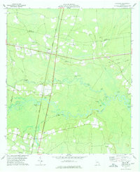
1978 Map of Hortense
USGS Topo · Published 1978About this map
The Seaboard Coast Line railroad creates a north-south axis through the Georgia coastal plain, intersecting with the east-west highway near Hortense. This landscape is defined by the wandering path of the Satilla River and the Little Satilla River, which create a complex network of oxbow lakes such as Bonnet Lake, Pollys Lake, and Spring Lake. These waterways served as vital points of access, noted by numerous landings including Spell Landing and Strickland Landing.
Find a feature on this map
41 named features on this map. Tap any name to fly to it.
Don’t see what you’re looking for? This feature index may not catch every label — zoom into the map to look around manually.
Map Details
Editions of this 1978 Hortense Map
This is the sole edition of this map. No revisions or reprints were ever made.
Other maps of this area

1917 · Nahunta
USGS Topo · 1:62,500

1918 · Hortense
USGS Topo · 1:62,500

1918 · Nahunta
USGS Topo · 1:62,500

1944 · Hortense
USGS Topo · 1:62,500

1946 · Brunswick
USGS Topo · 1:250,000

1948 · Brunswick
USGS Topo · 1:250,000

1953 · Waycross
USGS Topo · 1:250,000

1956 · Brunswick
USGS Topo · 1:250,000

1958 · Waycross
USGS Topo · 1:250,000

1961 · Brunswick
USGS Topo · 1:250,000