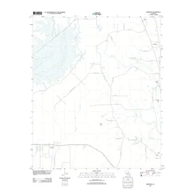
2012 Map of Hortman
USGS Topo · Published 2012About this map
The Bellevue Oil and Gas Field anchors the southwestern corner of this Webster Parish landscape, where industrial infrastructure meets a dense network of bayous and creeks. Reached by Bellevue Oilfield Rd, this area contrasts with the more rural settlement of Hortman to the northeast. The terrain is defined by complex water systems, including the wide wetlands of Bodcau Cr and the winding paths of Clarke Bayou and Pigeon Roost Bayou. For genealogists, the map is particularly detailed in its placement of local burial grounds, ranging from Edwards Cem in the north to Ratcliff Cem and Baten Cem in the southeast. Named local routes like International Paper Rd and Doc Steed Rd provide specific locational data for family researchers and those tracing the parish’s road development and land divisions into the early 21st century.
Find a feature on this map
40 named features on this map. Tap any name to fly to it.
Don’t see what you’re looking for? This feature index may not catch every label — zoom into the map to look around manually.
Map Details
Editions of this 2012 Hortman Map
This is the sole edition of this map. No revisions or reprints were ever made.
Other maps of this area

1922 · Sarepta
USGS Topo · 1:62,500

1924 · Sarepta
USGS Topo · 1:62,500

1932 · Bossier SE
USGS Topo · 1:31,680

1932 · Bossier NE
USGS Topo · 1:31,680

1947 · Minden
USGS Topo · 1:62,500

1948 · Bossier City
USGS Topo · 1:62,500

1949 · Minden
USGS Topo · 1:62,500

1950 · Plain Dealing SE
USGS Topo · 1:31,680

1955 · Shreveport
USGS Topo · 1:250,000
1955 · Bossier City
USGS Topo · 1:62,500