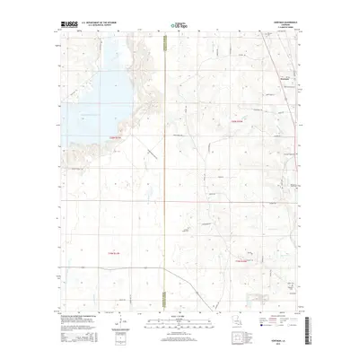
2015 Map of Hortman
USGS Topo · Published 2015About this map
Hortman serves as the primary settlement hub on this landscape, situated along the border of Bossier and Webster Parishes. The terrain is characterized by a complex network of waterways, most notably the Bayou Bodcau Reservoir and the meandering Clarke Bayou. These drainages shape the topography, creating a patchwork of lowlands and rising hills that define the local geography.
Find a feature on this map
16 named features on this map. Tap any name to fly to it.
Don’t see what you’re looking for? This feature index may not catch every label — zoom into the map to look around manually.
Map Details
Editions of this 2015 Hortman Map
This is the sole edition of this map. No revisions or reprints were ever made.
Other maps of this area

1922 · Sarepta
USGS Topo · 1:62,500

1924 · Sarepta
USGS Topo · 1:62,500

1932 · Bossier SE
USGS Topo · 1:31,680

1932 · Bossier NE
USGS Topo · 1:31,680

1947 · Minden
USGS Topo · 1:62,500

1948 · Bossier City
USGS Topo · 1:62,500

1949 · Minden
USGS Topo · 1:62,500

1950 · Plain Dealing SE
USGS Topo · 1:31,680

1955 · Shreveport
USGS Topo · 1:250,000
1955 · Bossier City
USGS Topo · 1:62,500