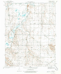
1938 Map of Horton
USGS Topo · Published 1977About this map
The Little Osage River and Marmaton River wind through this part of Vernon County, defining a landscape of wetlands and floodplains. In the late 1930s, this rural area was anchored by the settlement of Horton and a dense network of one-room schoolhouses that served the surrounding farmsteads. These institutions, including Humble Sch, Green Valley Sch, and East Washington Sch, illustrate the highly localized nature of rural education before mid-century consolidation. The presence of the County Farm and the Ellis Cem provides specific points of interest for genealogists tracing local residents. Transportation is dominated by the north-south route of the Missouri Pacific railroad, featuring Wales Siding, and the Missouri Pacific Highway, reflecting the corridor's reliance on rail and road for movement between the river bottoms and higher ground like Timber Hill.
Find a feature on this map
43 named features on this map. Tap any name to fly to it.
Don’t see what you’re looking for? This feature index may not catch every label — zoom into the map to look around manually.
Map Details
Editions of this 1938 Horton Map
2 editions found
Other maps of this area

1886 · Nevada
USGS Topo · 1:125,000

1887 · Butler
USGS Topo · 1:125,000

1894 · Butler
USGS Topo · 1:125,000

1894 · Nevada
USGS Topo · 1:125,000

1933 · Camp Clark
USGS Topo · 1:24,000

1934 · Papinsville
USGS Topo · 1:24,000

1936 · Rich Hill
USGS Topo · 1:24,000

1938 · Metz
USGS Topo · 1:24,000

1938 · Horton
USGS Topo · 1:24,000

1939 · Metz
USGS Topo · 1:24,000