
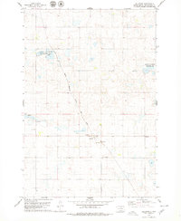
1978 Map of Hosmer NW
USGS Topo · Published 1979About this map
Glacial prairie potholes and marshy basins dominate this corner of McPherson County during the late 1970s. The landscape is defined by the National Waterfowl Production Area, which protects several larger water bodies and wetlands across the northern and eastern sections of the quadrangle. Human impact on the land is sparse and orderly, following the section lines of Townships 126 and 125 North. Near the southern boundary, the Congregational Cem and the nearby label for Graves indicate small, isolated pockets of community and family history amidst the agricultural expanses. Industrial activity is minimal, represented only by a solitary Gravel Pit and a mapped Well, reflecting the rural character of this Dakota plains region.
Find a feature on this map
8 named features on this map. Tap any name to fly to it.
Don’t see what you’re looking for? This feature index may not catch every label — zoom into the map to look around manually.
Map Details
Editions of this 1978 Hosmer NW Map
This is the sole edition of this map. No revisions or reprints were ever made.
Other maps of this area

1954 · Aberdeen
USGS Topo · 1:250,000

1956 · Aberdeen
USGS Topo · 1:250,000

1978 · Hillsview SE
USGS Topo · 1:24,000

1978 · Hosmer NE
USGS Topo · 1:24,000

1978 · Hosmer SE
USGS Topo · 1:24,000

1978 · Eureka East
USGS Topo · 1:24,000

1978 · Hosmer
USGS Topo · 1:24,000

1978 · Schumacher Lake
USGS Topo · 1:24,000

1978 · Schumacher Lake SW
USGS Topo · 1:24,000
1978 · Hillsview
USGS Topo · 1:24,000