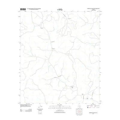
2012 Map of Hospital Ranch
USGS Topo · Published 2012About this map
Large cattle and livestock ranching operations define this West Texas landscape in the early 21st century. The map centers on the namesake Hospital Ranch, surrounded by a network of family-held territories including Glasscock Ranch to the northwest and Puckett Ranch to the southeast. These properties are connected by a sparse grid of graded thoroughfares like Ranch Road 1989 and more isolated tracks such as Private Road 4440, illustrating the remote nature of the terrain. Natural drainage patterns are dominated by seasonal watercourses like Willow Draw and Chalk Draw, which carve through the arid geography. This survey provides a clear view of the rural infrastructure of the Permian Basin region, showing how private access roads like Private Road 1130 link specialized sites like Red Mill Ranch and Kaiser Ranch to the larger county network.
Find a feature on this map
14 named features on this map. Tap any name to fly to it.
Don’t see what you’re looking for? This feature index may not catch every label — zoom into the map to look around manually.
Map Details
Editions of this 2012 Hospital Ranch Map
This is the sole edition of this map. No revisions or reprints were ever made.
Other maps of this area

1954 · Sonora
USGS Topo · 1:250,000

1958 · Sonora
USGS Topo · 1:250,000

1967 · Nolen Draw
USGS Topo · 1:24,000

1967 · Savell Ranch
USGS Topo · 1:24,000

1967 · Ozona SE
USGS Topo · 1:24,000

1967 · Shafter Draw
USGS Topo · 1:24,000

1967 · Crockett Heights
USGS Topo · 1:24,000

1967 · Hudspeth Draw
USGS Topo · 1:24,000

1967 · Caverns Of Sonora
USGS Topo · 1:24,000
1967 · Hospital Ranch
USGS Topo · 1:24,000