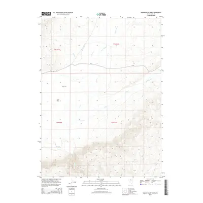
2014 Map of Hot Lake
USGS Topo · Published 2014About this map
Squaw Valley Ranch and the broader Squaw Valley landscape define this high-desert region of Elko County, where water management is central to the local geography. The presence of the High Line Canal alongside numerous drainages like Scraper Springs Cr and Rock Cr illustrates a complex system of irrigation and natural runoff supporting ranching operations. In the southern portion of the quadrangle, Hot Lake serves as a distinctive hydrological landmark. The terrain is traversed by CR-724, providing essential access across the open range. The intersection of natural watercourses such as Willow Cr and Ivanhoe Cr with established ranching infrastructure highlights the enduring relationship between the environment and land use in this part of northern Nevada.
Find a feature on this map
15 named features on this map. Tap any name to fly to it.
Don’t see what you’re looking for? This feature index may not catch every label — zoom into the map to look around manually.
Map Details
Editions of this 2014 Hot Lake Map
This is the sole edition of this map. No revisions or reprints were ever made.
Other maps of this area

1955 · McDermitt
USGS Topo · 1:250,000

1959 · McDermitt
USGS Topo · 1:250,000

1965 · Sixmile Hill
USGS Topo · 1:24,000

1965 · Willow Creek Reservoir
USGS Topo · 1:24,000

1965 · Squaw Valley Ranch
USGS Topo · 1:24,000
1965 · Midas
USGS Topo · 1:24,000

1965 · Rock Creek Ranch
USGS Topo · 1:24,000
1965 · Willow Creek Reservoir SE
USGS Topo · 1:24,000

1973 · Little Rock Creek
USGS Topo · 1:24,000

1977 · Scraper Springs
USGS Topo · 1:24,000