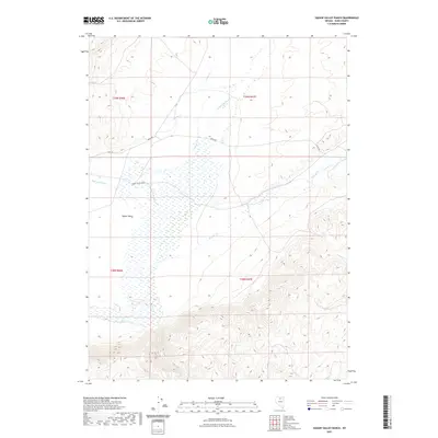
2021 Map of Hot Lake
USGS Topo · Published 2021About this map
Squaw Valley unfolds across this Elko County landscape, defined by a complex network of seasonal drainages and water management features. The Squaw Valley Ranch sits at the heart of the valley, supported by the High Line Canal and nearby Hot Lake. This 2021 survey illustrates the intersection of traditional ranching geography with modern infrastructure, where established routes like Midas Rd and Main St provide transit across the basin. The hydrology is dominated by numerous creeks, including Squaw Cr, Frazer Cr, and Willow Cr, which snake through the terrain towards the center of the valley. The map details the transition from the level basin floors to the rising relief found in the eastern sections, particularly around Ivanhoe Cr and Rock Cr, providing a clear view of how water and topography dictate the placement of ranching operations in the Great Basin.
Find a feature on this map
16 named features on this map. Tap any name to fly to it.
Don’t see what you’re looking for? This feature index may not catch every label — zoom into the map to look around manually.
Map Details
Editions of this 2021 Hot Lake Map
This is the sole edition of this map. No revisions or reprints were ever made.
Other maps of this area

1955 · McDermitt
USGS Topo · 1:250,000

1959 · McDermitt
USGS Topo · 1:250,000

1965 · Sixmile Hill
USGS Topo · 1:24,000

1965 · Willow Creek Reservoir
USGS Topo · 1:24,000

1965 · Squaw Valley Ranch
USGS Topo · 1:24,000
1965 · Midas
USGS Topo · 1:24,000

1965 · Rock Creek Ranch
USGS Topo · 1:24,000
1965 · Willow Creek Reservoir SE
USGS Topo · 1:24,000

1973 · Little Rock Creek
USGS Topo · 1:24,000

1977 · Scraper Springs
USGS Topo · 1:24,000